You can bolt radar mounts to your truck, stack cameras on the dash, and wire every laptop known to humankind, but if you don’t move with purpose, a storm will punish your mistakes in minutes.
Why Tactics Matter More Than Horsepower
Tactical storm chasing is about deliberate decision-making under intense atmospheric pressure. The storms don’t care that you’re excited; they care only about physics. To dance close, you need a repeatable system.
Here is the step‑by‑step blueprint I use on every serious chase day.
Step 1: The Pre‑Chase Briefing (90–120 Minutes Before Departure)
Before I even start the engine, I run through a personal "operations briefing." You don’t need a team or a fancy van—just discipline.
1. Define the Target Zone
Use:
- SPC outlooks (synoptic overview)
- HRRR/NAM 3km (convection timing and evolution)
- Surface observations (mesonet, METARs)
- Dewpoints ≥ 60–65°F pooling ahead of a boundary
- Backed surface winds (SE or ESE) beneath southwest flow aloft
- Developing dryline bulges or triple points
Look for:
Pick a primary target town and a secondary bailout zone. Draw an imaginary rectangle where you expect the best storms from 20Z–01Z.
2. Establish Hard Limits
Write these down or say them out loud:
- Maximum hail size you’re willing to risk (e.g., up to 1.75" / golf‑ball)
- Minimum distance you’ll keep from a tornado
- No‑go zones (urban cores, dense forest, mountains after dark)
When the sky turns green and your heartbeat spikes, these pre‑set rules keep you from making creative but lethal decisions.
Step 2: Gear Check With a Survival Mindset
Storm chasing is as much about redundancy as it is about optics.
Essentials:
- Primary and backup navigation: GPS, offline maps, paper atlas
- Redundant communications: phone, hotspot, portable battery, text-based check‑ins
- Weather data: at least two radar apps + satellite imagery
- First aid & basics: trauma kit, water, snacks, blankets
- Vehicle prep: full tank, good tires, wipers, functional lights, glass coverage if possible
Remember, you’re not just chasing storms—you’re potentially driving into the aftermath. Power outages. Downed lines. Debris fields. You need to be able to self‑sustain for hours.
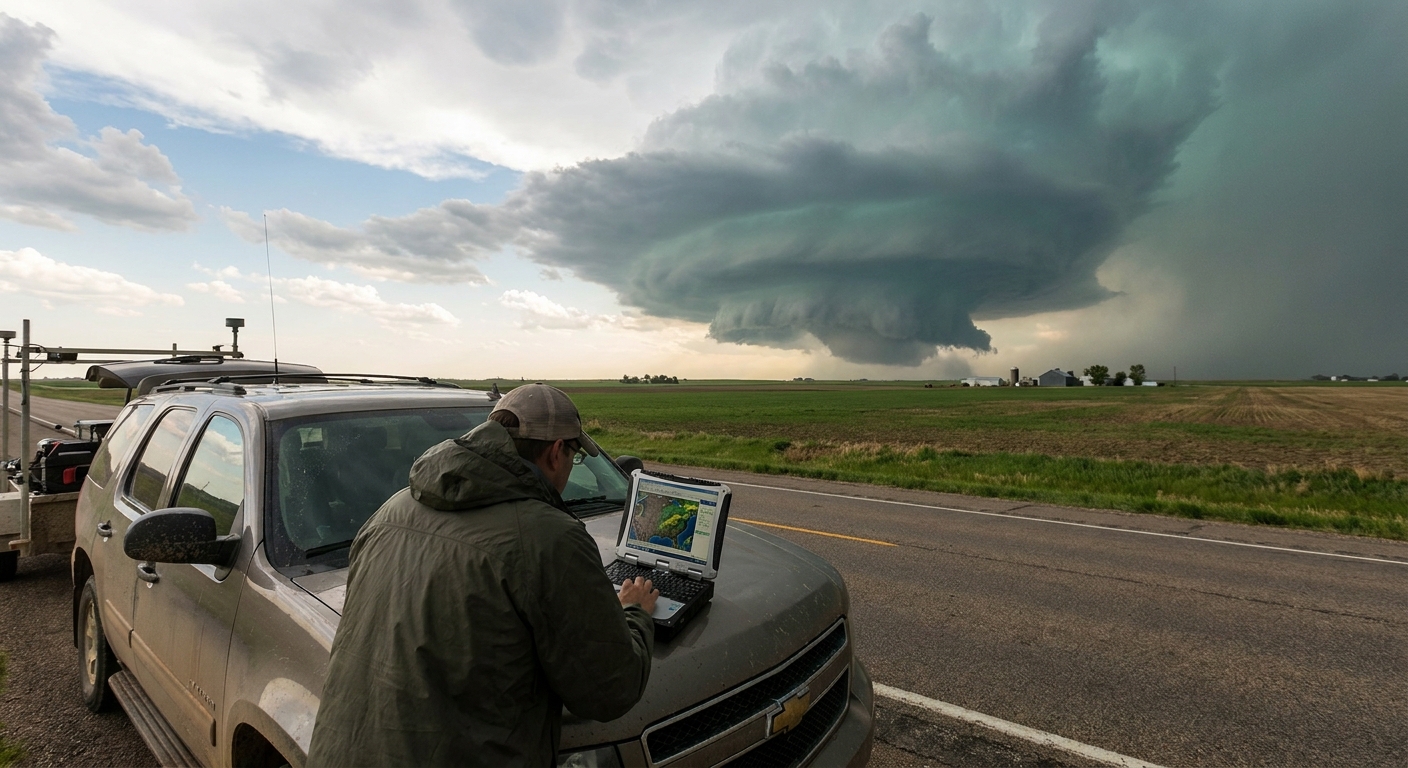
Step 3: Approaching the Target – Live Mesoscale Tuning
Once you’re rolling toward your target, the forecast becomes a negotiation.
Watch the Mesoscale Analysis
Sites like SPC’s mesoscale analysis and local WFO pages are gold. Monitor:
- Surface theta‑e and moisture convergence
- Mesoscale boundaries (outflow, warm fronts)
- Hodographs at key locations
Are surface winds backing more than expected? Is the outflow boundary sagging farther south? Adjust your intercept plan in real time.
In the Field: Visual + Data Blend
Out the windshield:
- High‑based cumulus or altocumulus castellanus indicate steep mid‑level lapse rates
- AGitated cumulus with vertical growth signal cap eroding
- Dust lines or subtle wind shifts reveal hidden boundaries
On radar:
- Watch for early discrete cells on the edges of initiation zones
- Avoid congested clusters unless your goal is structure, not tornadoes
The tactical move is to commit early to one dominant storm, not zigzag between multiple weakening cells.
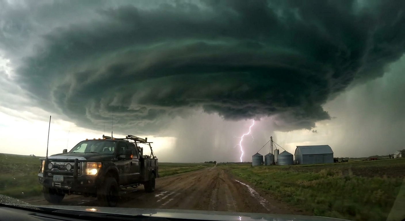
Step 4: The Intercept Geometry – Staying Ahead of the Circulation
Think of each supercell as a moving machine with distinct hazard zones.
The Four Key Quadrants
Inflow Region (SE–E of Storm)
- Cleaner air, best views of wall cloud and structure - Your primary chase and filming zone
Forward Flank (N–NE of Updraft)
- Heavy rain, hail, reduced visibility - Occasional embedded circulations
Rear-Flank / Hook Region (SW of Meso)
- Tornado genesis often near hook/inflow interface - Dangerous if you misjudge RFD surges or hail
Anvil Region (Far Downshear)
- Lightning hazard, large-scale precip
Your objective is simple: live in the inflow region, maintain line‑of‑sight to the mesocyclone, and never let the core pass between you and safety.
Tactical Moves
- Approach from the south or southeast so the storm crosses the road ahead rather than chasing you from behind.
- As the storm matures, stair‑step east and occasionally north to maintain a 1–5 mile distance from the meso.
- If the storm accelerates, be willing to drop it and reposition to a newer cell in a better road grid.
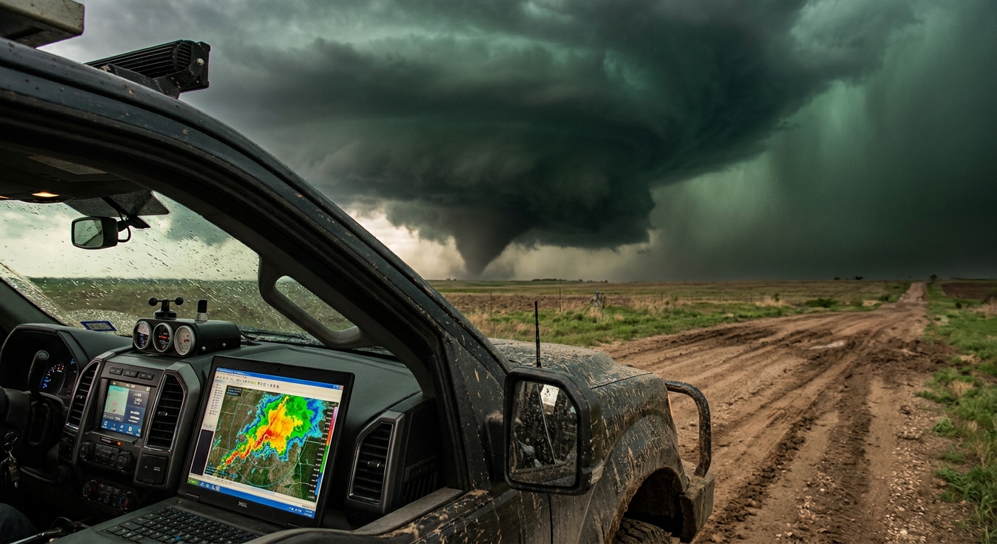
Step 5: Radar Tactics in the Heat of the Moment
In the field, radar is your nervous system. Here’s how I cycle through data under pressure.
Reflectivity Workflow
- Zoomed‑out view: Confirm storm motion, neighboring cells, line evolution
- Zoomed‑in view: Inspect hook, notch, and reflectivity gradients
Red flags:
- Rapid tightening of hook echo
- Reflectivity "ball" on the end of the hook (tornado vortex signature or debris)
- Sudden forward surge of heavy returns (possible RFD punch)
Velocity Workflow
- Toggle lowest 2–3 tilts for low‑level rotation
- Watch for couplets that persist and strengthen across successive scans
- Compare radar-estimated storm motion with your actual visual perception
If you see a tightening couplet and the wall cloud in front of you begins to spin harder, you should already know which direction you’ll bail if it drops a tornado and hooks right.
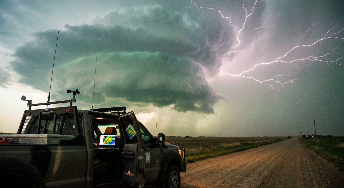
Step 6: Safety Protocols When the Adrenaline Peaks
The closer you get, the harder it is to think clearly. This is where rituals help.
Non‑Negotiable Rules in the Field
Never drive into zero visibility
If you can’t see the road, you can’t see water over it, power lines, or other chasers.
Avoid the convoy trap
Large chase convergences create traffic jams in prime intercept zones. Build alternate routes and give yourself more distance.
Respect lightning
Don’t stand outside next to your tripod under the vault region. Lightning can strike miles away from the core.
Night Chasing = Reduced Radius
After dark, I double my preferred distance from any rotation and rely heavily on radar + spotter networks.
Never Become the Story
If damage is imminent or already occurring, your camera takes a back seat to helping, reporting, or at least staying out of the way of emergency services.
Step 7: Debrief – Turning Chaos Into Experience
When the chase ends—whether in a dusty sunset or under a bruised, quiet sky—tactical chasers do one last critical step.
Debrief:
- Save radar loops of your storm
- Compare your positions and photos to storm reports and tracks
- Identify 2–3 decisions you’d change next time
Ask yourself:
- Did I ever lose my escape route?
- Did I let excitement override my limits?
- Did I misread any boundaries or radar signatures?
This feedback loop is how you build instincts that feel like "gut calls" later. They’re not magic—they’re just accumulated, analyzed experience.
Storms Don’t Negotiate, But You Can Be Ready
Chasing will always carry risk; we are operating in the near‑field of violent, rotating convection. But risk doesn’t have to mean recklessness.
With a tactical plan, strict safety protocols, and a relentless curiosity about what the atmosphere is trying to do, you can intercept surgically—closer, clearer, and safer.
The storms won’t slow down for you. Your only options are to get smarter, get more disciplined, and chase like your next decision actually matters.
Because out there, it does.