There’s a distinct moment when a chase day flips from casual scanning to absolute focus.
The Moment the Day Turns Real
For me, it was 4:23 p.m. on a May afternoon in central Kansas. Radar pings lit up my screen—a lonely cell on the dryline had just intensified. Within two scans, the reflectivity core blossomed, and a subtle kink in the velocity field hinted at early rotation.
By 4:30, that storm was no longer a forecast problem. It was my problem.
What follows is a blow‑by‑blow walkthrough of decision-making under a real tornadic supercell—how radar, sky, and roads collide when seconds matter.
1. First Echoes: Deciding to Commit
On the HRRR earlier, initiation was projected near a dryline bulge by late afternoon. We’d staged about 40 miles east, knowing we could move quickly once a storm fired.
When the first reflectivity blip appeared:
- Location: Near the dryline, south of the warm front intersection
- Instability: 2500–3000 J/kg MLCAPE
- Shear: 40–45 kt deep-layer, curved hodographs
The storm rapidly ramped from 35 dBZ to 55+ dBZ in under 20 minutes.
Decision: We commit. No hedging, no waiting for a "better" storm. On potent days, the first robust, isolated cell often becomes the show.
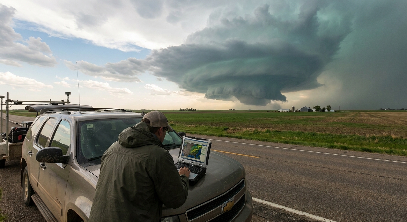
2. En Route: Using Radar Without Losing the Horizon
We headed west, using a tablet mounted low on the dash—close enough to glance at, far enough that the windshield still dominated our vision.
Radar Checkpoints Every 5–10 Minutes
Reflectivity Structure
- Core strengthening on the north side - Hints of a developing inflow notch on the south
Velocity
- Weak, broad rotation at mid‑levels - Nothing tight yet, but a consistent trend toward organization
Storm Motion
- Moving NE at ~25 mph; we adjust routes to stay SE of projected track
I force myself into a routine: quick checks, then eyes back to the sky. Radar should inform your chase, not hypnotize it.
3. First Visual Contact: Trusting Your Eyes Again
By 5:05 p.m., the storm crested the horizon.
Visually, it was everything the radar implied:
- Explosive updraft, hard edges, crisp cauliflower textures
- Anvil fanning NE, backsheared slightly against the upper winds
- Inflow bands feeding into a darkening base
The base, initially high, began to lower. Chunks of scud rose steadily into a nascent wall cloud.
Decision: We slow down, reposition slightly south and east. This storm is our world now.
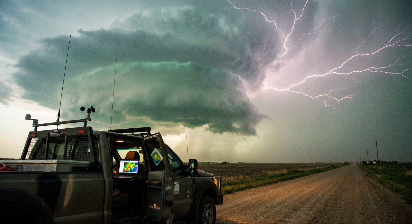
4. Radar Escalation: When Rotation Becomes Urgent
Back on radar, the change was unmistakable.
Reflectivity
- A definitive hook echo began carving out on the southwest flank.
- The reflectivity gradients near the hook tightened—evidence of strong inflow and wraparound precip.
Velocity
- Broad mid‑level rotation sharpened into a more defined couplet.
- On the lowest tilt, inbound and outbound velocities increased with each scan.
A Special Weather Statement was quickly upgraded to a Tornado Warning.
Decision: We reposition to a paved east road, staying about 3–4 miles ESE of the mesocyclone, with multiple south/east escape options.
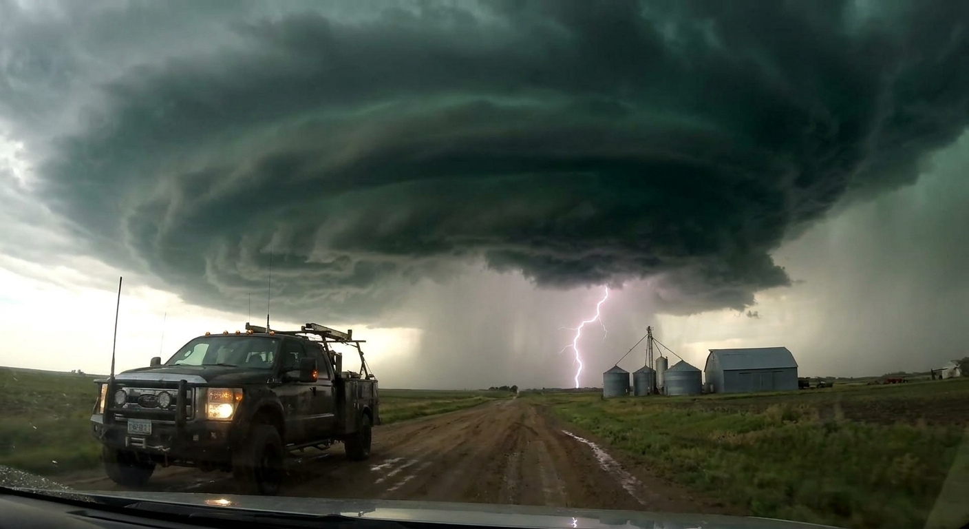
5. Under the Base: Reading the Wall Cloud
We pull off on a gravel road just south of the main east highway. The wall cloud is now obvious, hanging low, with inflow visibly streaming into it.
Key observations:
- Rotation: Initially slow and lumpy, then progressively smoother and faster.
- Vertical motion: Fragments of scud rise and wrap around the lowering.
- RFD: A bright, rain‑free slot erodes a notch on the west side of the meso.
You can feel the shift—wind direction backs and strengthens, warm and moist, funneled straight into the storm.
The atmosphere feels coiled.
Decision: We hold our ground but re‑check our escape routes. If a tornado drops and hooks right (common for right‑moving supercells), we’ll need to drop south, then stair‑step east.
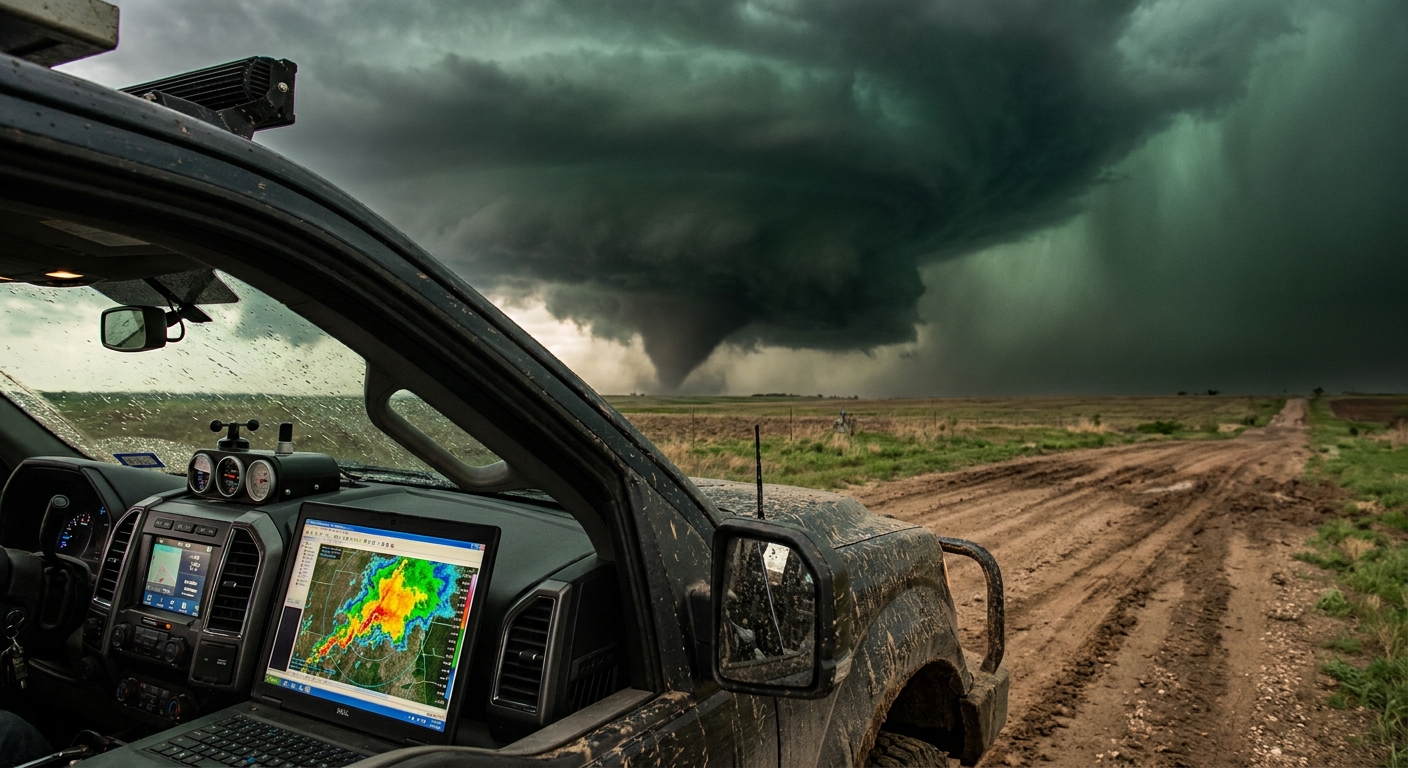
6. Tornado Genesis: When Seconds Matter
Around 5:32 p.m., the wall cloud transitions abruptly:
- Rotation tightens dramatically.
- A funnel begins to emerge from the center of the wall cloud, thin at first.
- Dust kicks up beneath it over a field—briefly disorganized, then clearly connected.
A tornado has formed.
On radar, the velocity couplet tightens into a textbook TVS (tornado vortex signature). Reflectivity shows the hook wrapping more aggressively.
Decisions in Rapid Sequence:
- Distance Check – We’re ~2.5–3 miles ESE, good for now.
- Motion Estimate – Visually, the tornado drifts ENE, slightly right of storm motion.
- Route Plan – If it accelerates or occludes closer, we drop south one mile, then continue east.
We roll video, but the camera is secondary. The real work is watching for subtle changes in motion and structure.
7. Occlusion and the Hook Right
As the tornado matures, the RFD surges.
- New rain curtains wrap around the circulation.
- The tornado’s motion shifts, beginning a rightward jog, common during occlusion cycles.
- Debris begins to loft higher, while condensation fluctuates.
On radar, the couplet makes a visible right turn relative to previous scans.
Decision: We don’t chase under the occluding meso. Instead, we drop south a mile, then push east to stay well ahead of the tightening circulation. We are not interested in being directly north of the hook.
The tornado intensifies briefly, a white rope embedded in gray curtains. Then, as the occlusion completes, it weakens, then lifts.
8. Cycling: The Second Tornado Threat
The storm isn’t even close to done. Supercells often cycle, spawning new low‑level mesocyclones as old ones occlude.
Signs of a new cycle:
- Fresh wall cloud forming slightly east/southeast of the old circulation.
- Radar shows a new velocity couplet developing closer to the inflow region.
- Old hook signature fades; a new kink emerges farther east.
Decision: We stay with the storm but increase our standoff distance to 5–6 miles. New development is messy, and terrain ahead becomes slightly more rolling.
Around 6:05 p.m., the storm produces a second, shorter‑lived tornado—mostly rain‑wrapped and partially obscured. This reinforces our choice to hang back.
9. Transition and Exit Strategy
As the evening progresses, additional cells fire along the boundary, and our once‑isolated storm begins interacting with neighbors.
- Radar shows clustering and hints of linear segments forming.
- Inflow becomes less focused; storm motion increases.
- Lightning activity spreads along a broader line.
This is often when a discrete supercell day transitions to a messy MCS.
Decision: We call it. We log our final position, grab last structure shots, and begin a methodical retreat to the east—never driving into the core, never cutting across damage paths without extreme caution.
10. Debrief: Lessons Burned Into Muscle Memory
Back at the motel, exhausted and wired, we replay the day.
Key takeaways:
- Early Commitment Paid Off – Locking onto the first dominant discrete cell gave us ideal angles all day.
- Escape Routes Were Everything – Each reposition was deliberate; we never boxed ourselves in.
- Radar + Visual Alignment – The most urgent moves came when radar signatures and visual cues aligned: tightening velocity + rapidly rotating wall cloud.
We compare GPS logs to radar loops and storm reports, refining our internal model of how storms behave vs. how we think they behave in the field.
Why This Story Matters More Than the Photos
It’s easy to share curated stills and polished video and forget the decisions underpinning them: the exits we chose not to take, the roads we refused to gamble on, the times we backed off instead of diving closer.
Real‑time storm chasing is a constant negotiation between fascination and survival.
You chase because you’re pulled toward the raw mechanics of the atmosphere, and you stay alive by letting science and discipline drive your choices when the sky turns violent.
Every tornadic supercell writes its own script, but the decision framework repeats: commit early, position intelligently, read radar and sky in tandem, and always know where you’ll go before the beast makes its next move.