Before a siren blares or a warning appears on your phone, the atmosphere has already started telling its story. As storm chasers, our job is to learn the language of that sky, to read the clues long before the first wall cloud forms over the horizon.
The Sky Always Speaks First
Every classic chase day begins with subtle hints: veering surface winds, a hazy moisture plume creeping north, mid‑level clouds racing overhead at impossible speeds. Put together, they whisper one word: supercells.
This is how I read the beast before I ever put the truck in drive.
Step 1: Morning Models and the Anatomy of a Chase Day
On big days, the urgency starts before sunrise.
I’m looking for three ingredients:
Instability (CAPE)
- Convective Available Potential Energy (CAPE) is the fuel. - Chase-worthy days often show 2000–4000 J/kg in the warm sector. - Watch for steep mid‑level lapse rates (7–8°C/km); they sharpen up the updrafts.
Shear (Deep-Layer and Low-Level)
- 0–6 km bulk shear over 35–45 kt supports organized supercells. - 0–1 km shear and storm-relative helicity (SRH) over 150–200 m²/s² raise tornado potential.
Lift and Boundaries
- Drylines, cold fronts, outflow boundaries, and warm fronts are the spark. - Supercells love intersections: where a dryline collides with a warm front, you often get the storm of the day.
I flip through HRRR, NAM, and the high‑res convection-allowing models (CAMs), not for a perfect forecast, but for trends. Are they consistently firing storms along the same corridor? Are hodographs curving more as we approach 00Z? By 10 a.m., I usually have a target town circled—subject to the atmosphere’s final say.
Step 2: Visual Cues – When the Sky Starts to Boil
Once you’re in the target area, the atmosphere stops being lines on a map and starts becoming a living, rotating animal.
Watch for:
1. High Plains "Turkey Towers"
Early in the day, you might see skinny, explosive updrafts that build and collapse—so‑called turkey towers. When these start:
- Aligning along a boundary
- Sustaining vertical growth
- Casting deep, textured shadows
…you’re looking at the first attempts of the atmosphere to break the cap.
2. The Explosive Updraft
The storm you want often starts with a single, dominant updraft that outperforms the rest:
- Rock-hard, cauliflower tops
- Rapid vertical growth visible minute by minute
- Tower that overshoots anvil level
When you see that one tower start to punch through and spread an anvil downshear, you feel it in your chest: this is the one.
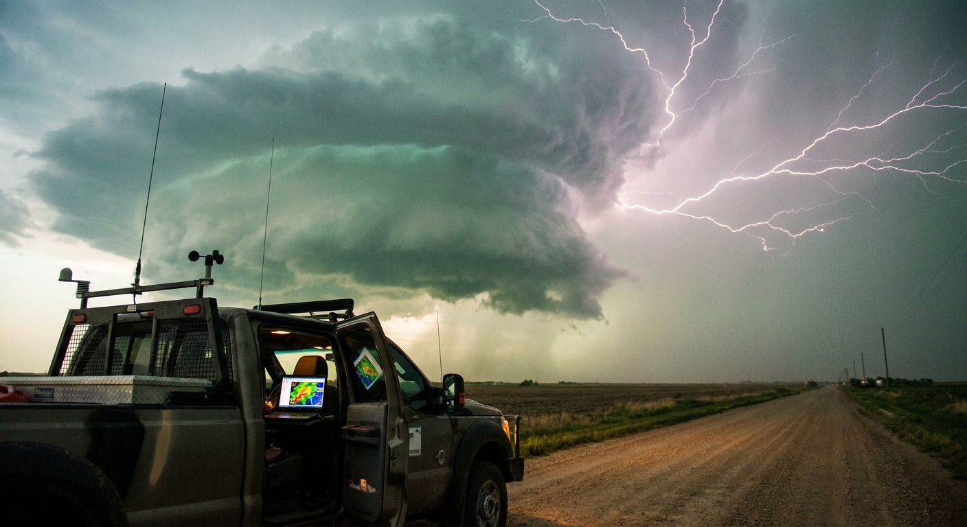
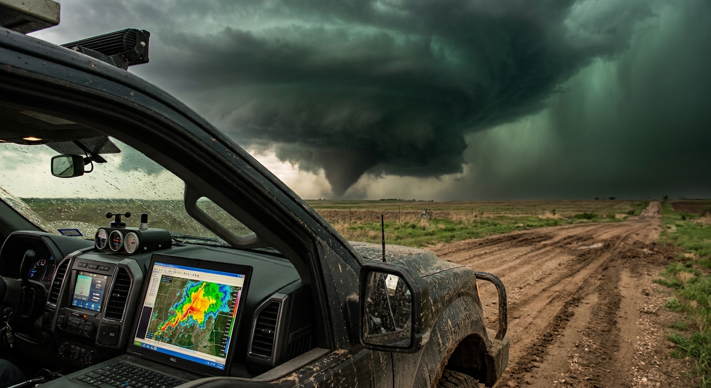
Step 3: Radar – Reading Rotation Before It Touches Dirt
I run dual radar apps: one for big-picture awareness, one zoomed in on my storm. Radar is both translator and lifeline.
Reflectivity: Structure and Threats
Key signatures to watch:
- Hook Echo: A classic wrapping appendage on the southwest flank. Indicates strong inflow and mesocyclone.
- Bounded Weak Echo Region (BWER): A weak echo under a strong reflectivity core—evidence of a powerful updraft lofting precipitation.
- Forward-Flank Downdraft (FFD): The heavy rain/hail core north/east of the meso. Get caught there and you’ll quickly lose visibility.
Velocity: Where the Storm is Twisting Itself Apart
I live on the velocity panel:
- Look along the inflow notch and hook region
- Seek tight couplets of inbound/outbound velocities
- Watch for strengthening and tightening rotation over multiple scans, not just a single spike
An intensifying couplet + persistent low‑level rotation on several tilts = the kind of urgency that moves you carefully south and east to maintain your escape routes.
Step 4: Field Positioning – The Chess Game With a Moving Monster
Storm chasing is a constant geometry problem with deadly stakes.
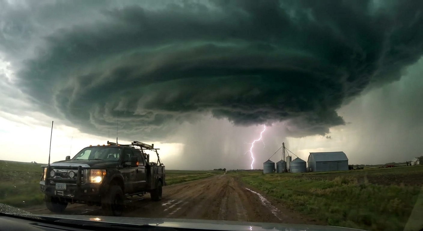
Preferred Spot: Southeast to Due East of the Meso
For classic supercells in the Plains:
- Stay ESE to SE of the updraft
- Keep the rain-free base and wall cloud in view
- Avoid the FFD core to your north and the hook hail to your west/southwest
The goal is to:
- Maintain visual of the wall cloud and any tendrils descending
- Stay one or two good east options ahead of the storm
- Prevent getting "cored" (hail and blinding rain) or flanked by new development
Safety Protocols While Mesmerized
Even when the structure is hypnotic, protocols are non‑negotiable:
Escape Routes First, Photos Second
- Before stopping, identify at least two ways out: usually east and south. - If you don’t have them, you’re too close or poorly positioned.
Never Park on the Road
- Pull fully off the shoulder. - Keep your vehicle pointed toward your escape path.
Respect RFD and Hail Cores
- Rear-Flank Downdraft (RFD) surges can wrap rain and hail around the meso, hiding tornadoes. - Giant hail can knock out windows and ruin visibility in an instant.
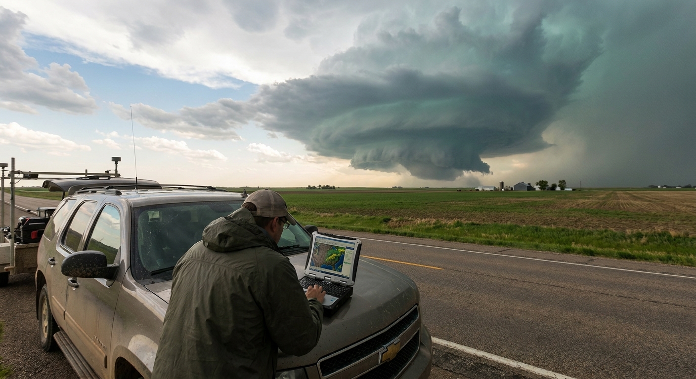
Step 5: Anatomy of a Classic Supercell in the Field
Let’s walk through what you might see from first tower to mature storm.
Early Stage
- Isolated updraft dominating the skyline
- Tower sharpens, glaciates at the top
- First anvil spreads downshear; inflow tails start forming
On radar: a growing, isolated return with increasing reflectivity and early signs of storm splitting.
Mature Stage
Visually:
- Striated, stacked-plate updraft
- Pronounced rain-free base with a lowering on the southwest side (wall cloud)
- Inflow band feeding into the meso
- Barrel updraft rotation visible on time-lapse
On radar:
- Classic hook echo on reflectivity
- Tight velocity couplet on lowest tilts
- Weak echo region under the core on higher tilts
This is when the atmosphere feels electric. Surface inflow roars into the storm, flags snap sideways, dust streaks across fields. If a tornado is going to form, it’s usually here.
Step 6: When Rotation Tightens – Staying Smart in the Most Intense Moments
When a wall cloud begins rapid, cyclonic rotation, the visual urgency spikes:
- Rising, rotating motion in the wall cloud
- Tail cloud feeding into the circulation
- Condensation funnel forming, then stretching toward the ground
Your job isn’t just to document—it’s to stay ahead of the evolution:
- Don’t chase directly into the notch if you can’t see.
- Don’t assume rain = safety; rain‑wrapped tornadoes kill.
- If the RFD surges and visibility tanks, reposition before you lose situational awareness.
Set a personal minimum distance you won’t violate (for me: 0.75–1 mile on violent days, more in hilly or wooded terrain). Tornado motion is not always straight-line, and satellite vortices can orbit the main circulation.
Why We Keep Coming Back
Every supercell is the atmosphere pushing itself to the limit—shear, instability, and lift weaving into a single, rotating engine. We chase not because we underestimate the danger, but because we understand the physics well enough to stand at the edge of it and come home.
The more you learn to interpret models, radar, and the sky itself, the less you’re gambling and the more you’re tracking a living process with respect and precision.
The beast will always be bigger than us. Our edge is knowledge, discipline, and the willingness to walk away when the sky stops making sense.
That’s how you read a supercell—and live to read the next one.