Most safety talks assume you’re at home, watching from a basement. But storm chasers operate in the kill zone—wedges crossing highways, rain-wrapped circulations, debris fields you drive into before you see them.
When Tornado Safety Isn’t Theoretical Anymore
If you chase long enough, you will eventually misjudge a jog in storm motion, lose data at the worst time, or find a road dead-ending into a barbed-wire fence with the roar getting louder.
This guide is tornado safety tuned for the field: urgent, tactical, and written from the perspective of someone who’s had to improvise escape routes while the pressure drops and the sky rotates overhead.
The Mindset: Science First, Ego Last
Tornado science tells us that storms can:
- Occlude and drop a new tornado unexpectedly close.
- Turn right of their motion vector as the mesocyclone intensifies.
- Embed circulations in rain for QLCS/HP setups with almost no visual cue.
If your mindset is “I’ll get closer than everyone else,” the atmosphere will eventually cash that check.
Swap it for:
- “I want the best data and visuals from a survivable position.”
- “I expect storms to make unforecast, abrupt moves.”
- “I prize options over proximity.”
Pre-Chase Safety Setup: Decisions in the Calm
Vehicle Readiness
- Fuel: Start full; never drop below half a tank on big days.
- Tires & brakes: Tornado science is useless if you can’t outrun RFD on wet roads.
- Chargers and mounts: Radar, GPS, and mapping must be rock solid.
Emergency Gear
Minimum kit:
- Helmets (bike or climbing) for all occupants.
- Sturdy shoes and gloves (for walking debris fields).
- First aid kit with tourniquets, trauma dressings, and eye protection.
- Portable weather radio for NWS warnings if data dies.
- Paper maps of chase region.
Stow this where you can reach it in seconds, not buried under camera bags.
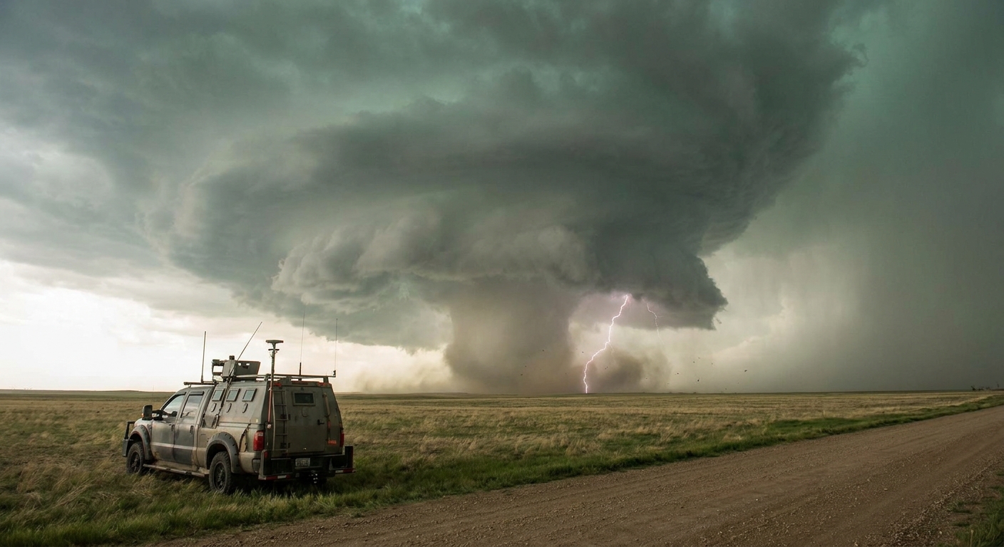
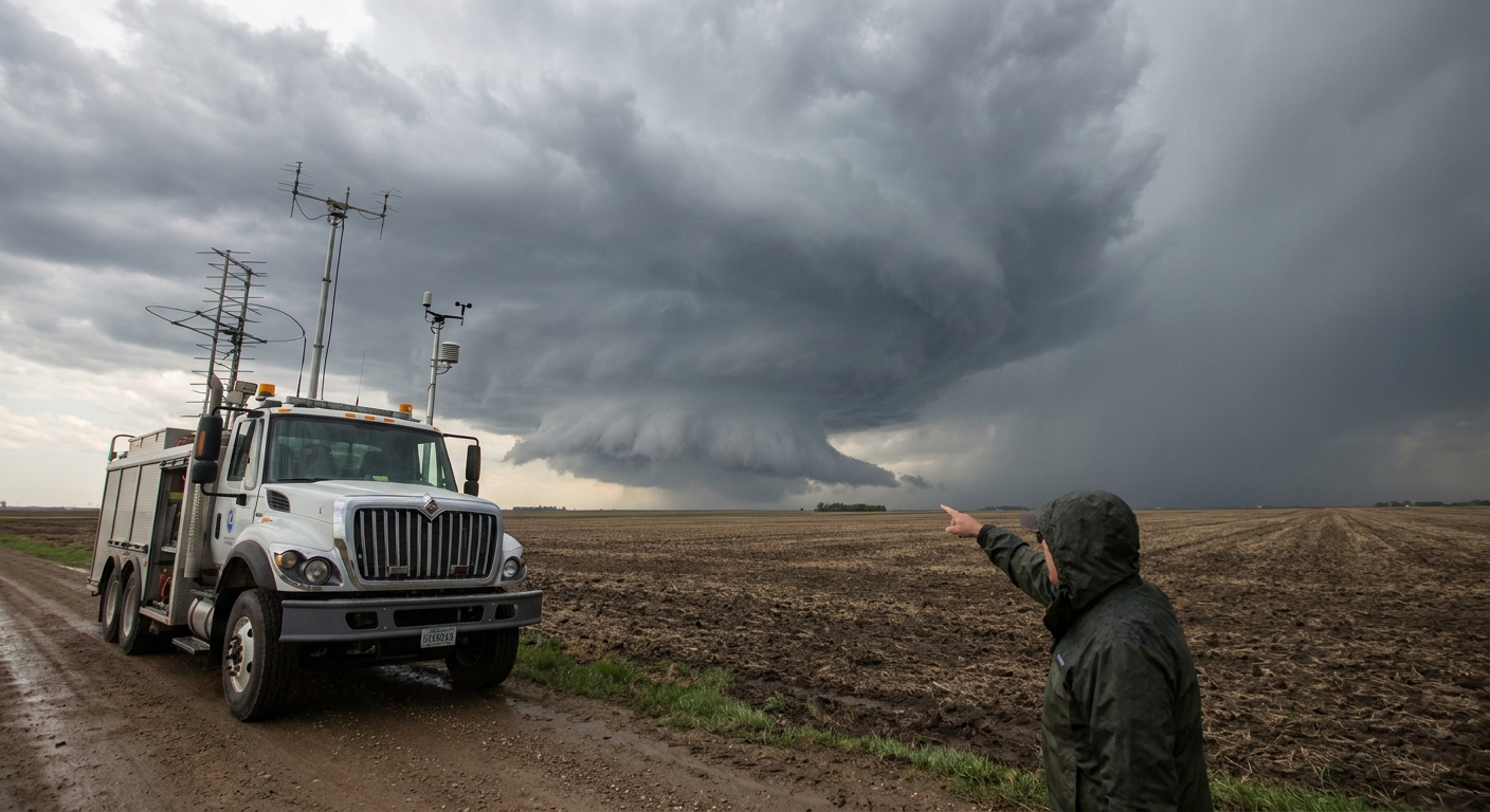
Positioning: Where Tornado Science Meets Road Reality
Ideal Viewing Sectors
In a classic, isolated supercell:
- East to northeast of the mesocyclone gives best view of the base and a clear escape route east.
- Southeast quadrant can work in flat terrain, but be cautious of storm turning right into you.
Bad sectors:
- Directly under or just southwest of the mesocyclone—you’re in the hook, RFD, and hail.
- Northwest of the storm—behind the mesocyclone with poor visibility and debris.
Terrain and Road Grids
Before the day starts:
- Identify river crossings, dead-end networks, and forested hills.
- Favor grid-style road networks (Kansas, parts of Oklahoma) over broken terrain (Ozarks, parts of Dixie Alley).
The same EF2 you’d easily avoid on the Plains can trap you in a river valley when there’s only one road.
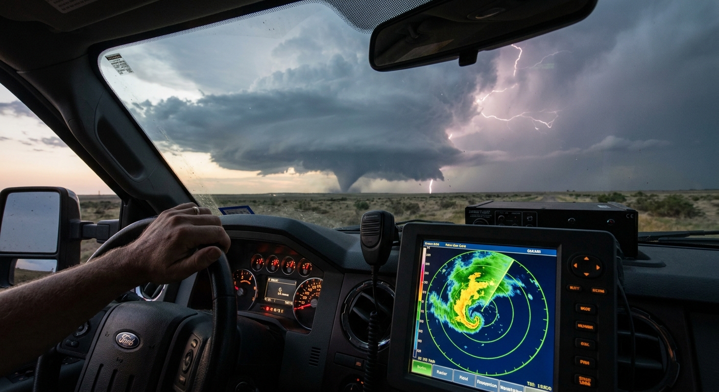
Using Radar for Real-Time Safety Calls
Safety hinges on reading radar like your life depends on it—because it does.
Key Radar Safety Flags
- Tightening velocity couplet approaching your line of travel.
- Hook echo making a sudden right turn into your path.
- Debris ball emerging on reflectivity with a low-CC signature—confirmed damaging tornado.
Rules of Thumb
- If the velocity couplet is within 5 miles and you can’t visually confirm the base, you are too close.
- Treat any TDS (Tornadic Debris Signature) within 10 miles as an immediate reason to re-evaluate your position.
- If radar updates stop, assume worst-case motion and give extra buffer.
Field Scenarios and How to Survive Them
Scenario 1: The Hook Overtakes You
You’re north of an east-moving storm, thinking you’re safe. The storm turns right, and the hook swings toward your road.
What to do:
- Immediately drive east or southeast if available.
- Do NOT drop south into the hook unless you have visual confirmation it’s safe.
- Use cross roads to stay ahead of the inflow notch, not inside it.
Science angle: Right turns signal a strengthening mesocyclone. Storm motion vectors can change sharply when rotation tightens.
Scenario 2: Rain-Wrapped Tornado in an HP Beast
HP supercells bury their mesocyclones in rain. You’re south or southeast of the storm with limited contrast.
What to do:
- Trust velocity and CC over your eyes.
- Stay farther east than you would for a classic supercell; increase standoff distance.
- Avoid punching the core to “get into the notch.” That notch is where people vanish.
Science angle: HP storms have heavy precipitation wrapping around the mesocyclone, obscuring tornadoes and making visual cues nearly useless.
Scenario 3: Data Dead Zone with a Suspect Base Nearby
The bars die just as the wall cloud starts spinning harder. You lose radar and GPS.
What to do:
- Immediately pause forward motion and reassess visually.
- Identify wind direction, rain curtains, and any rotating features.
- If in doubt, retreat east or south away from the updraft region.
- Use your paper map and compass/phone compass to avoid driving blind into the hook.
Science angle: Mesocyclones can tighten from broad rotation to tornado in a single scan. Without that scan, assume the dangerous outcome.
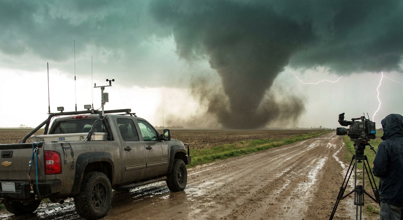
Scenario 4: The Tornado Suddenly Grows and Turns
A slender stovepipe you thought you understood rapidly widens and shifts track.
What to do:
- Assume the tornado can accelerate and deviate.
- Move at a right angle to the apparent storm-relative motion—usually east or southeast.
- Never drive parallel and close to the track; cross away at a safe distance or bail.
Science angle: Tornado motion is not identical to the parent storm motion. Occlusions, mergers with boundaries, and internal dynamics can sharply alter path.
If You’re Caught: Last-Resort Tactics
You’ve made every mistake, or the storm outplayed you. Options are gone.
Never Take Shelter Under an Overpass
Wind tunnel effect increases wind speeds and focuses debris. We’ve seen this go wrong.
Better Than Nothing Options
- Find a deep roadside ditch or low spot, away from trees and vehicles.
- Lie flat, protect your head and neck with arms and helmet.
- Avoid drainage areas during heavy rain; flash flooding can become lethal fast.
If you’re in a sturdier structure (gas station, store):
- Get to interior rooms away from windows.
- Stay off wide-span roofs (gyms, big-box stores) if possible.
After the Passage: Transition from Chaser to First Responder
Once the tornado has passed and you’re safe:
- Report your precise location, tornado path, and visible damage to NWS or 911.
- Approach damage areas slowly—watch for live power lines, gas leaks, nails, and unstable debris.
- Render first aid only if you can do so safely and are trained.
- Document carefully but respectfully. People’s worst day is not your content farm.
Tornado science is not just about the vortex; it’s about impact and survival.
Why We Don’t Quit After the Close Call
Every seasoned chaser has stories that begin with “We got too close when…” and end with some mix of humility and disbelief they’re still here.
The atmosphere doesn’t care how many years you’ve chased or how many tornadoes you’ve logged. It only cares about physics. Your job is to understand that physics well enough—and to build habits strict enough—that you can keep witnessing these violent experiments without becoming part of the debris field.
Chase hard. Study obsessively. But when the inflow roars and the sirens start, remember: the most important statistic you can collect each season is that you made it home.