On a tornadic day, your windshield lies to you. Rain curtains hide rotating bases, terrain blocks your view, and the storm morphs faster than you can drive. Radar is the only reason many chasers—including me—are still alive.
Why Radar Is Your Lifeline When the Sky Goes Sideways
This is a radar-first playbook: how to read signatures in real time, how to fuse them with what you see out the window, and how to make split-second chase decisions without gambling your life.
Know Your Tools Before You Roll
Before you even leave the hotel parking lot:
- App choice matters – Use a radar app with:
- High-resolution Level II or III data
- Velocity and storm-relative velocity (SRV)
- Dual-pol products (Correlation Coefficient, Differential Reflectivity)
- Fast refresh and multiple radar site selection
- Data backups – Hotspot + secondary carrier if possible; radar is useless if you can’t pull it.
- Radar etiquette – Don’t chase solely off someone’s social media stream or low-bit-rate images. Go to raw data.
Reflectivity: The Skeleton of the Storm
Reflectivity is where you first glimpse how the storm is built.
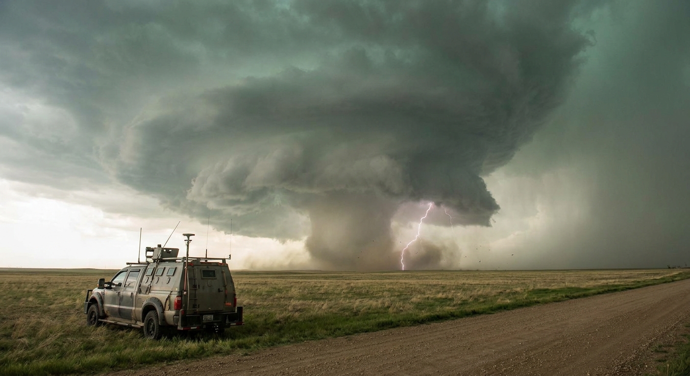
1. Classic Supercell Structure
On a tornadic supercell, key reflectivity elements:
- Flanking line off the southwest flank: smaller cells feeding into the main updraft.
- Main core to the north or northeast: heavy rain and hail.
- Hook echo wrapping around the south side: the hallmark of a mature mesocyclone.
The hook is your first big clue. It’s the radar imprint of the RFD wrapping around the updraft. A sharper, more defined hook often signals stronger low-level organization.
2. HP vs. Classic vs. LP
- Classic supercell – Clean hook, large but not overwhelming core, obvious inflow notch. Good chase targets if you can see the base.
- HP (High-Precipitation) – Hook and mesocyclone embedded in heavy rain; reflectivity max often wrapped around the circulation. These can hide violent tornadoes.
- LP (Low-Precipitation) – Weak reflectivity core, often just a skinny updraft and small hail core. Tornadoes possible but radar signatures can be subtle.
Knowing the storm mode tells you how much you must trust radar over your eyes.
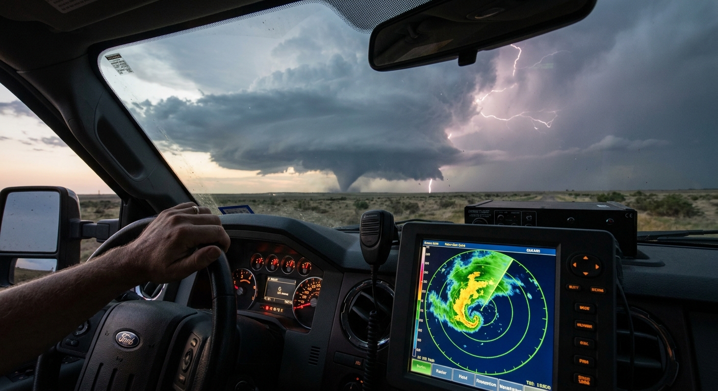
Velocity and SRV: Where the Tornado Lives
Reflectivity tells you where the storm is. Velocity tells you where it’s trying to kill you.
1. Basic Velocity Strategy
- Switch to storm-relative velocity (SRV) when available.
- Identify the radar site and storm’s approximate distance—aliasing and beam height matter.
- Look for tight inbound/outbound pairs (couplets) near the hook or inflow notch.
2. Interpreting a Velocity Couplets
Ask:
How tight is the couplet?
- Loose, broad couplet: broad rotation, may be a developing mesocyclone. - Tight, pixel-scale couplet: strong, focused rotation—tornado likely or imminent.
How strong is the shear?
- Large difference between inbound and outbound velocities (e.g., 60+ kt delta) indicates intense low-level vorticity.
How persistent is it?
- Brief, weak couplets can be transient. - Persistent, strengthening couplets through multiple scans are more concerning.
3. Altitude and Beam Height
The farther the storm from the radar, the higher the beam. A violent tornado 70 miles out can still look like modest shear at 5–6k ft AGL.
Use multiple nearby radars if possible, and don’t dismiss a marginal couplet at long range when the environment screams “tornado day.”
Dual-Pol: Confirming When Things Turn Serious
Dual-polarization radar lets you identify debris—and that’s when the chase changes.
Correlation Coefficient (CC)
- Tornadic Debris Signature (TDS) appears as a tight, low-CC (blue/green) area co-located with a strong velocity couplet and high reflectivity.
- A TDS confirms a tornado is not just down—it’s damaging structures or vegetation.
Why TDS Matters to Chasers
- Confirms ground contact when you can’t see the circulation.
- Indicates damage potential and urgency for calling in reports.
- Helps differentiate between radar artifacts and real, life-threatening events.
If you see a strong couplet, a tight reflectivity max, and a CC drop all in the same spot, treat it as a confirmed significant tornado—even if the view out your window is just gray curtains.
Fusing Radar with Real-World Positioning
Radar is meaningless unless you constantly relate it to where you are and where you’re headed.
1. Orient the Storm
- Track the motion vector – Most apps show storm motion arrows. Confirm visually: is the anvil blowing in the expected direction? Is the base where it should be relative to the core?
- Note the position of the hook or couplet relative to you:
- If it’s west/southwest and moving east/northeast: you’re ahead of it—classic viewing position.
- If it’s south or southeast moving toward you: you’re in danger of being overrun.
2. The Safe Sectors
General rules (with terrain caveats):
- Northeast / east of the mesocyclone – Often safest, with good view of the updraft base and escape routes east and north.
- Directly south of a hook – High-risk if the storm is HP. Tornado may be rain-wrapped.
- West of the mesocyclone – Dangerous without perfect visibility and roads; RFD and circulation can overrun you.
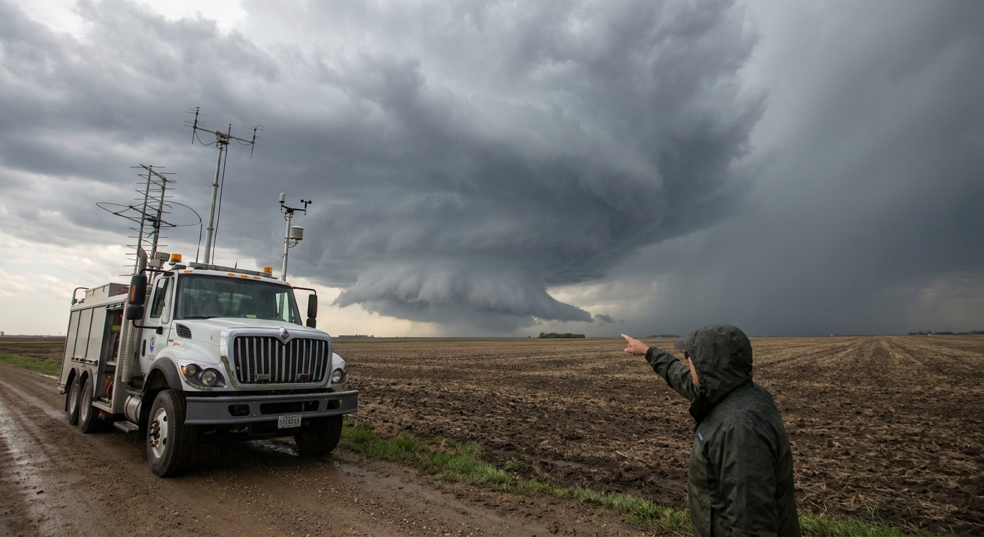
Case Study: When Radar Saved the Chase
Central Kansas, late spring. A classic right-moving supercell is cycling through updrafts. On reflectivity, the hook is textbook—sharp, clean, wrapping around a low-precip core.
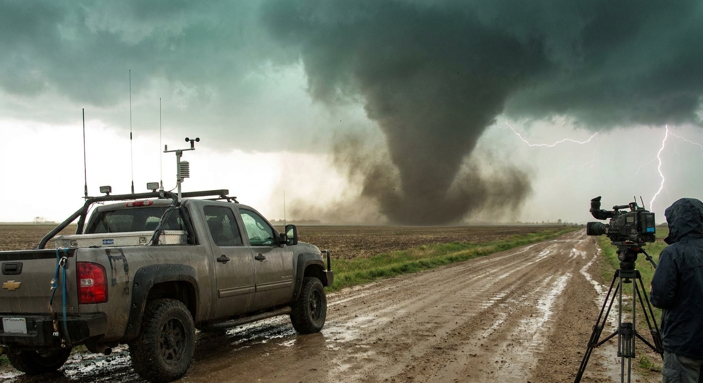
Visually, we see a rotating wall cloud, crisp inflow bands, and a dry slot—everything yelling “tornado soon.” Then the storm rapidly transitions to HP. Rain curtains sweep across the base; contrast vanishes.
On SRV, the couplet intensifies and tightens, but visually we see nothing—just dark gray and blinding bursts of rain. The appendage to our southwest on radar starts to curl closer than expected; the storm is turning more right than forecast.
Radar shows the circulation will cross the highway we’re on in 6–8 minutes.
We drop south two miles, then east. Thirty seconds after we clear the perpendicular road, emergency services report a large tornado crossing exactly where we were parked.
No view. No photogenic rope-out. Just data and trust.
Radar-Driven Safety Protocols for Chasers
Use this checklist when things escalate:
- Every scan, update your escape route.
- Ask: If the couplet jogs right 3–5 miles, am I still safe?
- If the couplet gets within 5 miles and you can’t see the base, reposition.
- Never sit still in rain or hail with a tightening couplet approaching.
- Treat TDS + strong couplet as maximum threat.
- You’re now dealing with a confirmed damaging tornado.
- Watch for rapid occlusion and cycling.
- When a couplet weakens and another spin-up forms just downstream, the storm may be cycling and shifting the danger zone.
- Respect line-embedded circulations.
- QLCS tornadoes can form fast, with messy signatures. Short lead time; give squall lines more clearance than your ego thinks necessary.
Why We Obsess Over Pixels
Every radar sweep is a heartbeat in the life cycle of a supercell. Chasers who survive season after season learn to read those heartbeats as if their lives depend on it—because they do.
Tornado science on the screen and in the sky are two sides of the same story. The more fluent you become in both languages, the more you can safely position, document, and understand these rotating monsters without becoming part of the debris signature yourself.