Most people remember the tornado. Storm chasers remember the boundary.
The Quiet Lines That Decide Everything
Again and again, the nastiest tornadoes I’ve seen didn’t just form on a generic dryline—they spun up where that dryline tangled with a warm front, an outflow boundary, or some subtle line you could barely see on surface obs. On satellite, they’re faint. On radar, they’re subtle. But in the field, they flip the switch from garden-variety supercell to violent, ground-scraping vortex.
This is a deep dive into how those boundaries work, how to spot them, and how to chase them without getting blindsided.
Boundaries 101: Invisible Rails for Supercells
A boundary is simply where air masses collide or transition:
- Dryline – Separates moist Gulf air from hot, dry continental air.
- Warm front – Warmer, moister air overrunning cooler air to the north.
- Outflow boundary – Cool, dense air left behind by older storms.
- Differential heating boundary – Edges between sun-baked ground and shaded/soil-moist areas.
These zones enhance lift, low-level shear, and vorticity, making them prime real estate for tornadogenesis.
Why Boundaries Supercharge Tornado Potential
1. Enhanced Low-Level Shear
Along boundaries, wind changes direction and speed over short distances. That means:
- More directional shear – Winds may back (turn more easterly) on the cool side.
- Localized vorticity – Spin is concentrated in thin corridors.
When a storm ingests this air, its low-level mesocyclone can intensify dramatically.
2. Extra Lift
Storms need a shove to break the cap. Boundaries provide that shove.
- Converging winds force air upward.
- Even on marginal CAPE days, boundary convergence can locally boost updraft strength enough to sustain a supercell.
3. Moisture & Temperature Contrast
Boundaries often mark sharp gradients in dew point and temperature. That can:
- Increase CAPE locally.
- Provide the cool side that helps shape the rear-flank downdraft (RFD) into a tornado-friendly rather than tornado-killing engine.
Finding Boundaries Before You Chase
If you’re not hunting boundaries, you’re chasing blind.
1. Surface Observations
Open up surface plots and look for:
- Dew point jumps of 5–10°F over short distances.
- Wind shifts (e.g., SE winds changing to E or NE across a narrow zone).
- Local pressure falls or kinks in isobars near where storms are forecast.
2. Satellite Imagery
On visible satellite:
- Thin cloud streets aligning along convergence lines.
- Sharp edges between cumulus fields and clear air.
- Differential heating boundaries where cumulus explodes along sun/shade transitions or snow/no-snow lines.
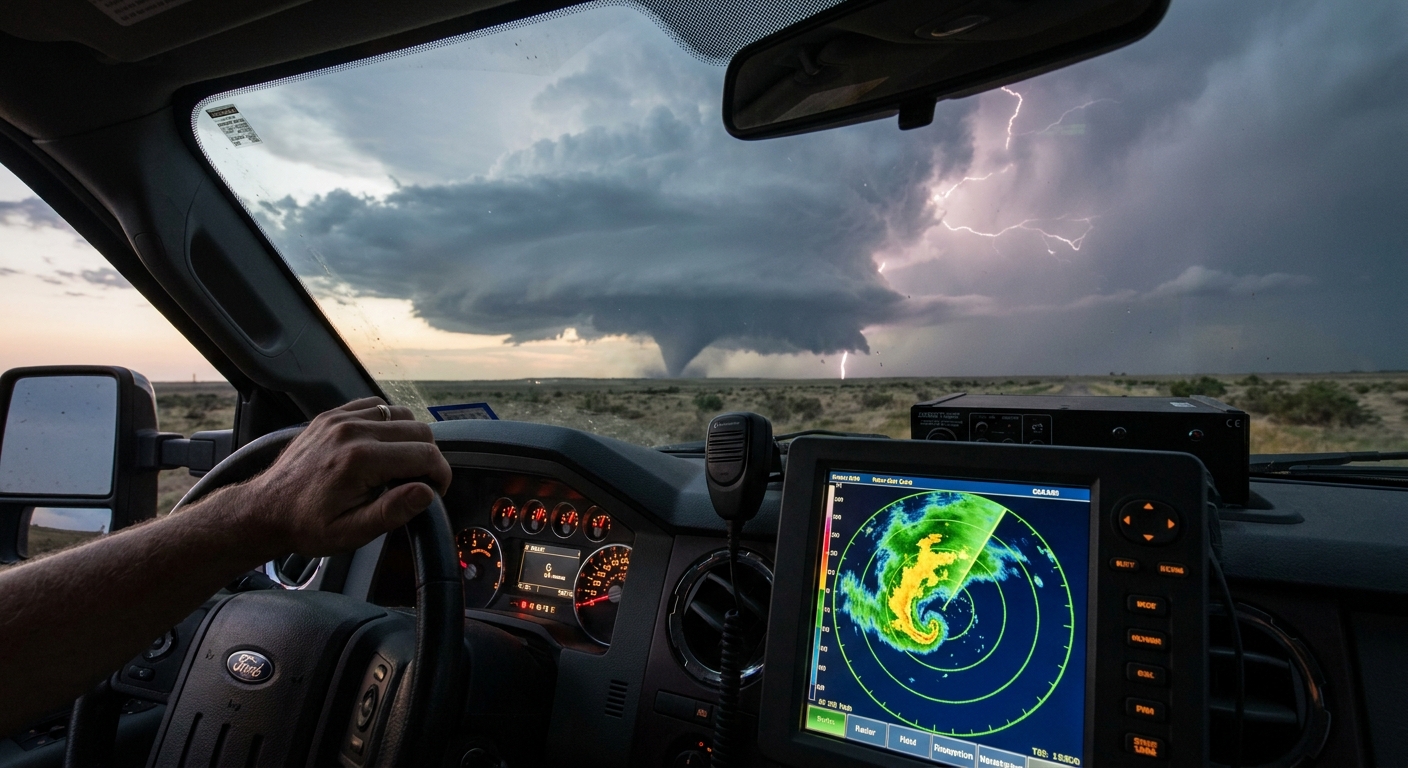
3. Radar Subtleties
Even on clear-air mode, radar can show boundaries:
- Fine lines of weak reflectivity from insects/dust along convergence.
- Arc-shaped signatures of old outflow boundaries curling away from decayed storms.
Overlay storms on top of these fine lines and you’ll often spot your future tornado producer.
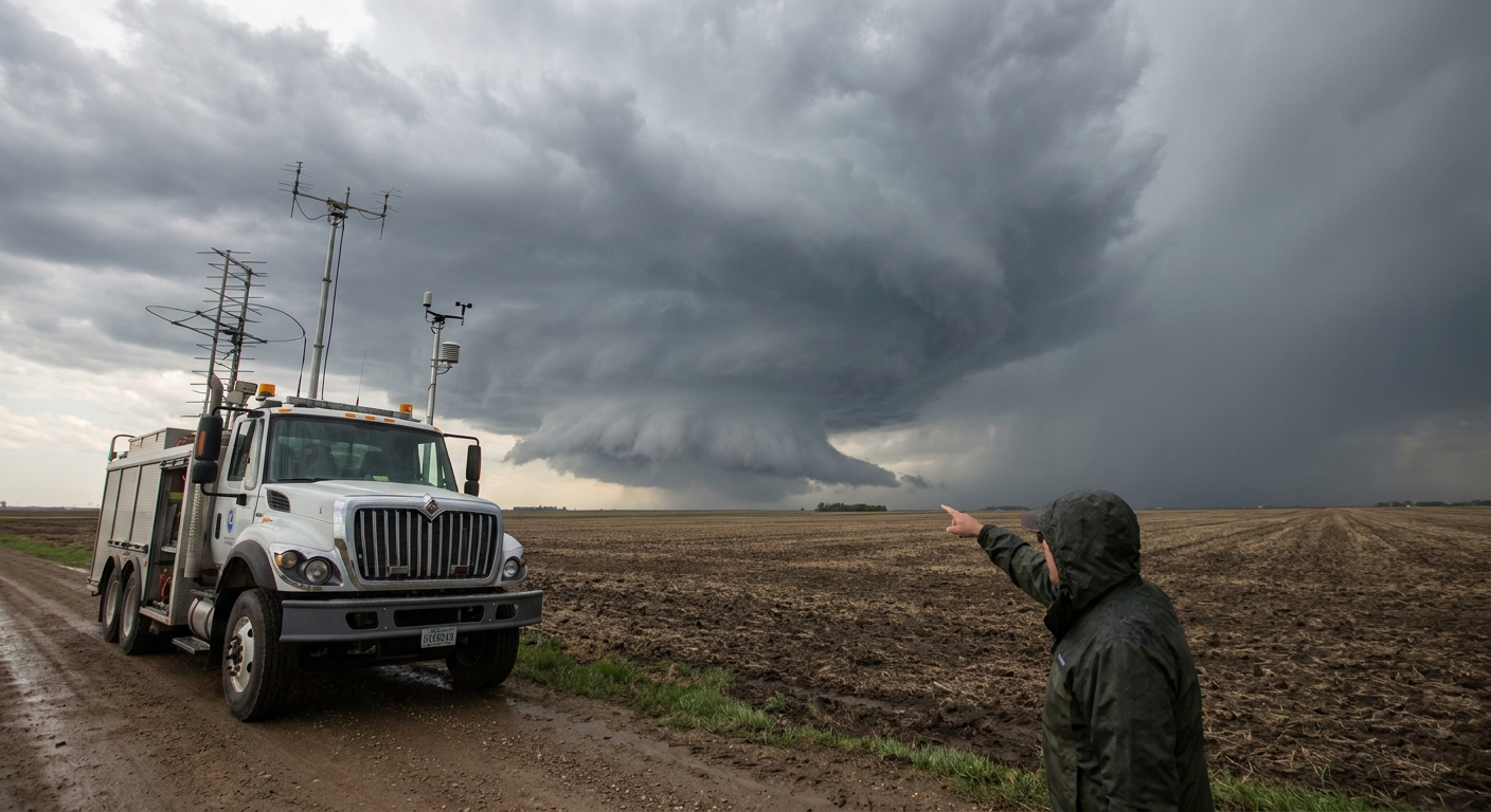
Boundary Interactions: Where Tornado Magic Happens
Some of the most prolific tornado producers form at junction points where boundaries collide.
Dryline + Warm Front
This combo is notorious:
- Storms form on the dryline.
- The strongest tornadoes often occur as a mature supercell interacts with or crosses the warm front.
- On the cool side of the front, surface winds back (turn more easterly or northeasterly), ramping up low-level shear.
Outflow Boundary + Supercell
Outflow boundaries from earlier convection can be game-changers:
- A storm crossing a cool outflow boundary into backed surface winds can suddenly intensify its low-level rotation.
- Tornadoes may favor the intersection of the supercell’s inflow corridor with the outflow boundary.
But beware: too cold an outflow pool can kill inflow and choke the storm.
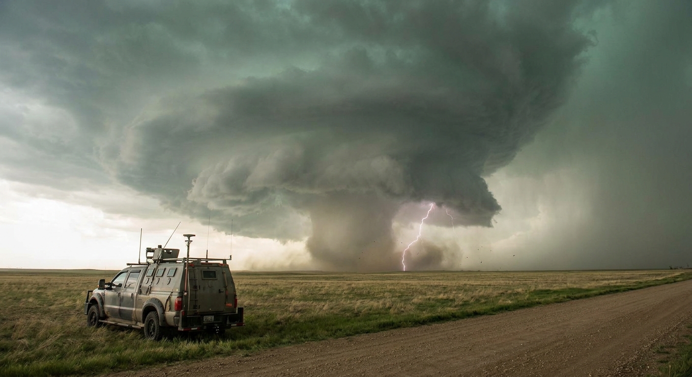
In the Field: Reading Boundaries with Your Senses
On a chase, boundaries are not just lines on a map. You can feel and see them.
Sensory Clues
- Temperature drop – Drive north across a warm front and you may feel an abrupt chill.
- Wind shift – Winds might go from SSE and smooth to E or NE and gusty.
- Low scud / ragged clouds clinging to the boundary line.
Visual Boundary Tells
- Lines of aggressively growing cumulus firing along a north-south line.
- A hazy, turbulent-looking seam on the horizon.
- Dust or smoke converging along an invisible line.
When a supercell approaches one of these, slow down. This is where storms wake up.
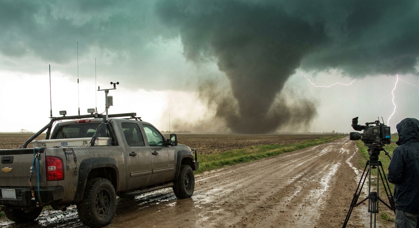
Case Study: Boundary-Crossing Monster
Eastern Nebraska, late May. The forecast target is a triple point—a meeting of dryline, cold front, and warm front. We commit early.
First storms form along the dryline, half-disorganized at first. One updraft steadily gains dominance. On surface obs, dew points jump from 62°F to 68°F just 20–30 miles east, marking the warm sector. To the north, temps and winds drop on the cool side of the warm front.
Our chosen supercell hugs the warm front edge. For an hour, it’s photogenic but non-tornadic: sculpted updraft, some rotation, but nothing on the ground.
Then the storm crosses the warm front.
- Surface winds turn from SSE to E, even ENE.
- The low-level jet begins ramping up around sunset.
- On SRV, the mesocyclone suddenly tightens and lowers in altitude.
In the field, the wall cloud deepens, scud rockets upward, and the inflow becomes a freight train. A cone tornado drops, then grows into a violent, multi-vortex wedge straddling the boundary.
Same storm. Different air mass. Entirely different personality.
Chasing Boundaries Without Dying on Them
Boundaries focus storms—and chasers. Things get crowded, chaotic, and dangerous fast.
Tactics
- Aim slightly downshear of the boundary intersection, not directly under it. Let the storm come to you.
- Use grids and sat imagery to avoid low-visibility routes when storms interact with cool air.
- Beware of sudden storm motion shifts as supercells latch onto a boundary and deviate right.
Safety Rules
- Don’t cross into cold, dense air behind an outflow boundary and park there, assuming the storm is “done.” It can re-intensify near the boundary.
- Don’t assume a storm is weak because it’s struggled ahead of the boundary. The flip can happen in one scan.
- Never put yourself between a storm and its boundary interaction point without a clean escape route.
Why Boundary Science Is Tornado Science
Tornado forecasting has evolved from chasing broad synoptic setups to obsessing over mesoscale features—subtle, fast-changing boundaries that decide which storm becomes the headline.
For storm chasers, this is the frontier: reading the sky and surface obs tightly enough that you’re already parked near the golden interaction zone before the first watch is issued.
You can’t control what the atmosphere does. But you can decide whether you’re ahead of the curve or chasing in the wake of the day’s real action. In tornado science, and in the chase, the difference is often just a boundary-width wide.