There’s a specific shade of green-black that makes every storm chaser sit up straighter in the driver’s seat. The air goes heavy, the wind shifts, and the world feels like it’s holding its breath. That’s the edge of tornado science—where equations on a whiteboard collide with wet asphalt, screaming inflow, and a mesocyclone tightening overhead.
The Moment the Sky Turns Dangerous
In this guide, we’re not just admiring the structure. We’re dissecting how the beast forms, what to watch on radar, and how to survive when your chase target decides to spin up right in front of you.
Building a Tornado: Ingredients vs. Recipe
Meteorologists love the classic ingredient list, and for good reason. Tornadoes are the violent byproduct of a very specific atmospheric recipe:
- Moisture – Deep low-level moisture, typically 60–70°F dew points (16–21°C), feeding the updraft.
- Instability (CAPE) – Convective Available Potential Energy often 1500+ J/kg, but structure can beat sheer quantity. Explosive updrafts come from pockets of strongly unstable air.
- Lift – Drylines, warm fronts, outflow boundaries, and subtle waves aloft that kick the parcel skyward.
- Wind Shear – The magic ingredient. Speed and directional shear with height, backing surface winds, and strong mid-level flow.
From Ingredients to Mesocyclone
The transition from “nice supercell” to “dangerous tornadic storm” hinges on how vertical wind shear organizes the updraft into a rotating column—a mesocyclone. At the surface, southeast or easterly winds bring in moist air; aloft, southwesterly winds rip over the top. That directional change with height creates horizontal vorticity that the updraft tilts and stretches vertically.
The stronger and more focused that rotation becomes, the more likely you are to see a tornado drop from the wall cloud.
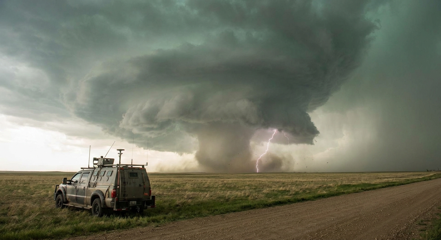
The Tornado Engine: Stretching, Vorticity, and the RFD
A tornado isn’t just a spinny thing under a cloud; it’s the end result of a delicate, violent balance.
1. Vertical Stretching
As the updraft intensifies, it pulls air upward faster. Conservation of angular momentum means that as a rotating column is stretched, it spins faster—like a figure skater pulling in their arms. This tightening of rotation can bring winds to tornadic intensity.
2. The Role of the Rear-Flank Downdraft (RFD)
The RFD is the hammer. It’s a descending surge of cooler, drier air wrapping around the backside of the mesocyclone. On radar, it often appears as a hook; in the field, it’s a surge of wind, dust, and sometimes bright, slanting rain curtains.
The right kind of RFD is crucial: slightly cooler than the environment but not so cold that it chokes off the inflow. When the RFD gust front wraps around and pinches the updraft, it can focus low-level vorticity and help a tornado spin up.
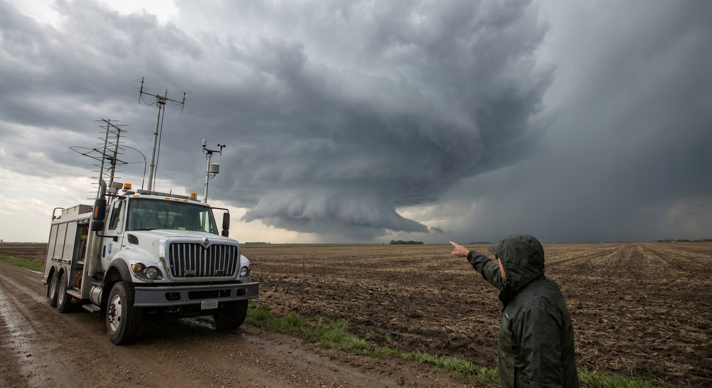
Reading the Sky: Visual Clues in the Field
You don’t need a supercomputer when the sky is screaming data at you.
Key Visual Features
- Persistent, rain-free base – Solid, flat, and dark with inflow bands feeding in.
- Wall cloud – Localized, lowered cloud base under the updraft, often rotating and pulling scud upward.
- Tail cloud / inflow feeder – Horizontally oriented cloud band feeding into the wall cloud from a precipitation core or boundary.
- RFD cut / clear slot – A bright, carved-out notch where descending dry air wraps around the updraft.
When a rotating wall cloud tightens, scud rises violently, and the clear slot wraps, you’re on the edge of tornadogenesis.
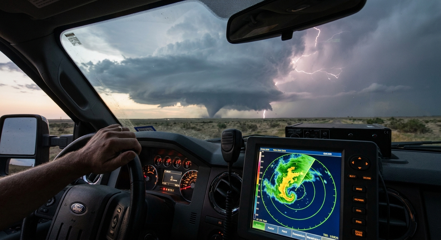
Radar: The Tornado Story in Pixels
Reflectivity: More Than Pretty Colors
- Hook echo – The classic signature: a hook of high reflectivity curling around the storm’s southern flank. It’s the radar imprint of the wrapped RFD.
- Debris ball – A tight, intense reflectivity max near the circulation center when the tornado is lofting debris. Usually co-located with strong velocity couplet.
Velocity: Where the Real Drama Lives
Use storm-relative velocity (SRV) whenever possible:
- Tight gate-to-gate couplet – Adjacent pixels of strong inbound and outbound velocities. The tighter and stronger the couplet, the more intense and focused the rotation.
- Low-level scans – Prioritize the lowest elevation angles; tornado signatures can be shallow initially.
Watch for a broad, intensifying mesocyclone that tightens over time. A broad, messy couplet evolving into a compact, high-contrast couplet is often the radar prelude to a significant tornado.
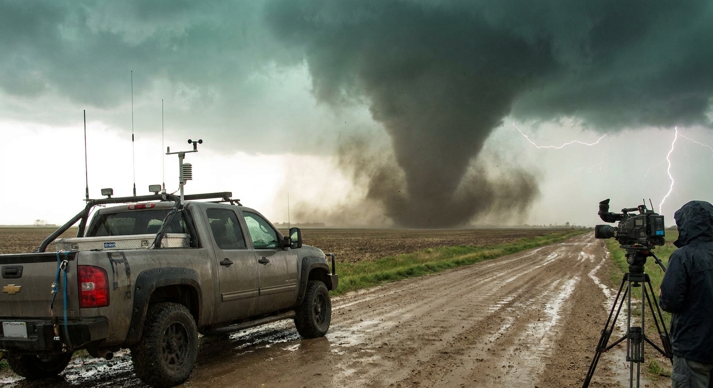
Field Notes: When the Road Disappears
A chase day on the Plains, late May. CAPE over 3000 J/kg. A bulging dryline draped across western Oklahoma, with a subtle surface low and a sharpening warm front.
By mid-afternoon, one storm dominates the visible satellite—overshooting top, anvil blowing downshear, and gravity waves radiating outward. We commit to it early.
On approach, the updraft tower is rock-solid with barber-pole banding—evidence of strong rotation. The base is rain-free, inflow warm and sticky, with steady 30–40 mph southerly winds.
Then the wall cloud forms. It’s slow at first, a lowered, rotating mass under the base. Within minutes, the RFD carves a hard clear slot—bright sky framing the wall cloud like a stage. Scud tears are ripped upward, condensing into a tightening column.
We reposition east to stay out of the hook. The couplet tightens on radar. On the horizon, a ghostly funnel snakes halfway down, then three-quarters, then all the way to the ground, dust swirling into contact.
In those seconds, every theory you’ve studied turns into screaming, rotating reality.
Safety Protocols When Science Turns Violent
Tornado science is useless if you don’t live to apply it.
Positioning
- Stay out of the notch if you don’t have a clean escape route east or southeast.
- Avoid the hook region unless you can see the base clearly and know your road network.
- Never drive into zero-visibility rain-wrapped cores; velocity may show a lurking circulation.
Core Rules for Chasers
- Maintain at least two escape routes (usually east and south/southeast).
- Keep fuel above half a tank; you will need to reposition fast.
- Don’t rely on one data source; cell networks fail. Pair radar with eyes, barometer, and storm motion.
- Have helmet, sturdy shoes, and first-aid kit within arm’s reach.
Why We Keep Going Back
Tornado science isn’t finished; it’s being rewritten with every dual-pol scan, every mobile radar deployment, every close pass by a research vehicle or seasoned chaser. We’re still learning exactly how often tornadoes form, intensify, and suddenly dissipate, and why some textbook days bust while marginal setups produce violent storms.
But that’s the pull: the unanswered questions hanging under a rotating base. If you chase, do it with respect—for the atmosphere, the people in the path, and the razor-thin margin we stand on when we park under a storm that’s trying to spin the world apart.
When the sky goes green and the inflow roars in your ears, remember: this isn’t just a show. It’s a living laboratory, and you are standing in the middle of the experiment.