The first time you spend hours with a single supercell—watching it form, organize, drop a tornado, cycle, and decay—you realize tornadoes aren’t random acts. They’re chapters in a storm’s biography.
Watching a Tornado Live Its Entire Life
In this explainer, we’ll walk stage-by-stage through a supercell’s life cycle, from the first towering cumulus to the final gasping updraft, with an eye on how and when tornadoes tend to emerge. Think of it as time-lapse tornado science, viewed from the driver’s seat and the radar screen at once.
Stage 1: Cumulus Towers and the Battle with the Cap
It starts quietly.
Warm, moist air at the surface butts up against a capping inversion—a layer of warmer air aloft that suppresses convection. The atmosphere is loaded but locked.
Visual Signs
- Flat cumulus fields that build slightly, then flatten again.
- Isolated towers that briefly rise above the rest.
Science in Play
- CAPE is primed, but the cap resists.
- Small-scale lift from boundaries or upper-level disturbances eventually pierces the cap.
When one tower breaks through and keeps going, you’ve just met your storm.
Stage 2: Towering Cumulus to Mature Updraft
Now the storm is in its growth spurt.
Visual Signs
- A rapidly growing, explosive updraft tower with cauliflower edges.
- The top begins to glaciate—flattening into icy anvil clouds.
- Overshooting top poking above the anvil if the updraft is strong enough.
Radar Clues
- Reflectivity core blossoms from a few dBZ to a solid, growing cell.
- Little structure yet—no hook echo, no defined mesocyclone.
Science in Play
- Parcel ascent is dominated by instability.
- Vertical wind shear hasn’t yet organized the updraft.
At this point, it’s a promising storm, but not yet a supercell.
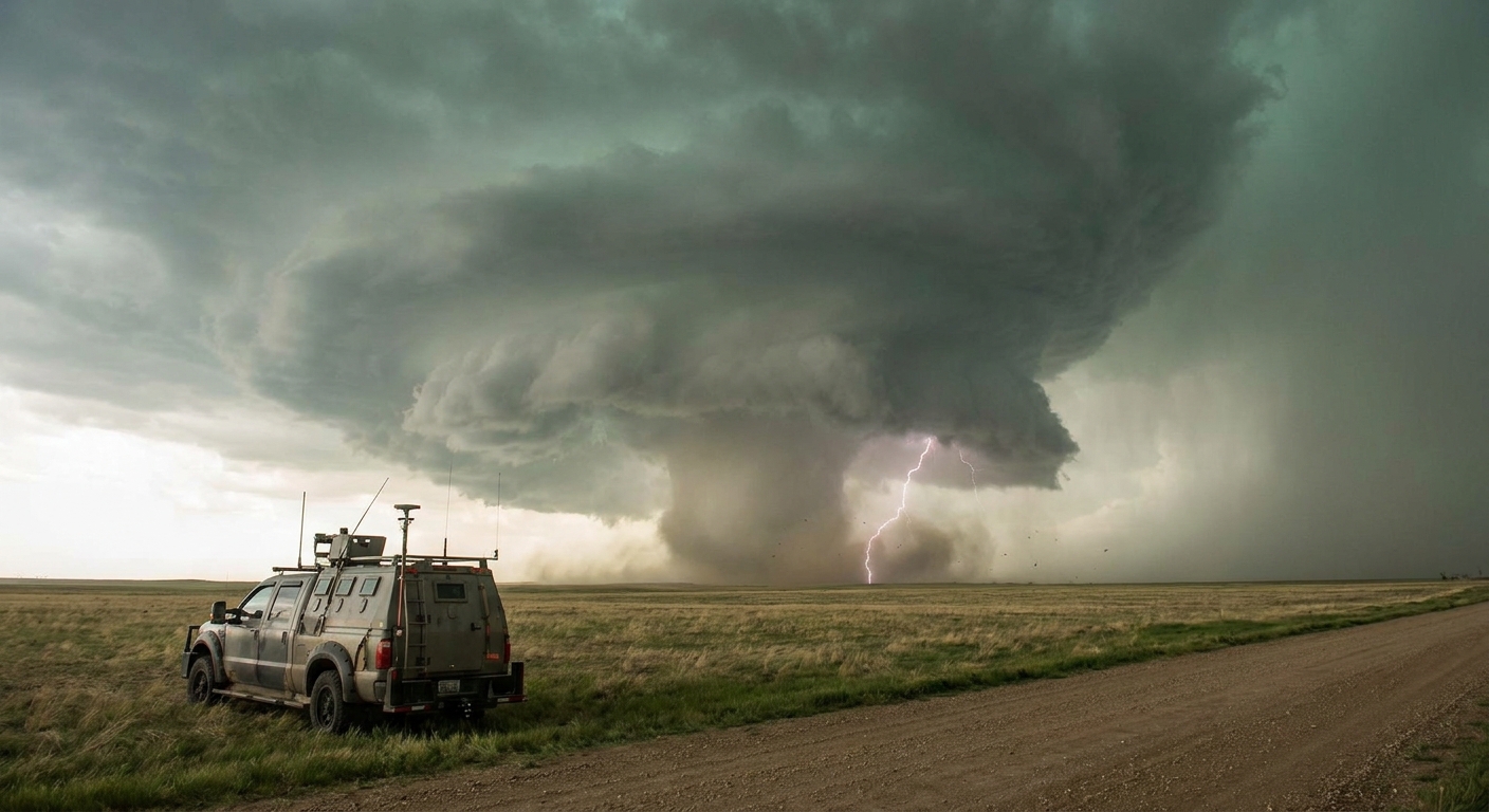
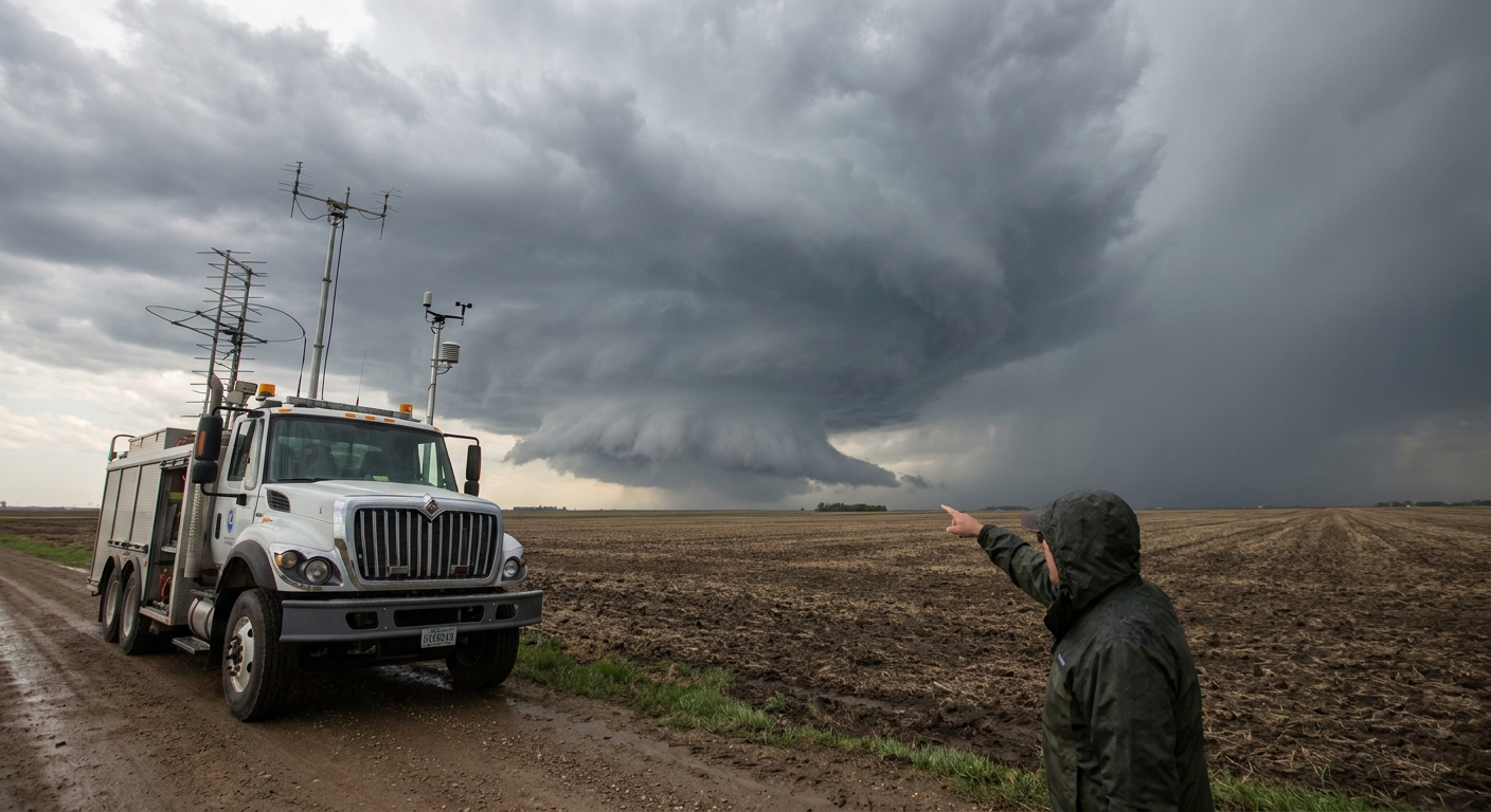
Stage 3: Supercell Organization and Mesocyclone Formation
This is where the storm graduates.
Visual Signs
- Updraft tilts and begins to rotate—a barber-pole look with banded structure.
- Rain-free base forms under the main updraft.
- Flanking line of smaller updrafts extends from the main storm.
Radar Clues
- Reflectivity shows a more defined core and maybe the beginnings of an inflow notch.
- Velocity starts to show broad rotation—a mesocyclone forming.
Science in Play
- Environmental vertical wind shear tilts and stretches horizontal vorticity into vertical.
- Updraft and downdraft become separated, feeding longevity.
Not every supercell becomes tornadic, but all significant tornadoes in the Plains are tied to organized rotation at this stage.
Stage 4: Wall Cloud and Tornadogenesis Window
This is the phase chasers live for—and fear.
Visual Signs
- A wall cloud lowers beneath the rain-free base, closer to the ground than surrounding cloud base.
- Inflow bands feed into the wall cloud; scud fragments rise and merge.
- RFD clear slot appears as bright, dry air punches around the mesocyclone.
- Rotation in the wall cloud tightens and accelerates.
Radar Clues
- A hook echo forms as the RFD wraps precipitation around the updraft.
- Storm-relative velocity shows a more concentrated low-level mesocyclone.
- On dual-pol, any existing debris might show as a low Correlation Coefficient area.
Science in Play
- The balance between updraft strength, low-level shear, and RFD temperature is critical.
- If the RFD is cool but not too cold, it can help focus vorticity along its leading edge.
This is the tornadogenesis window—often 10–60 minutes where conditions are primed for a tornado to form.
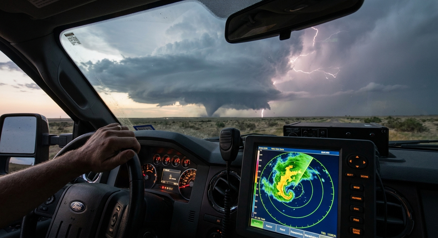
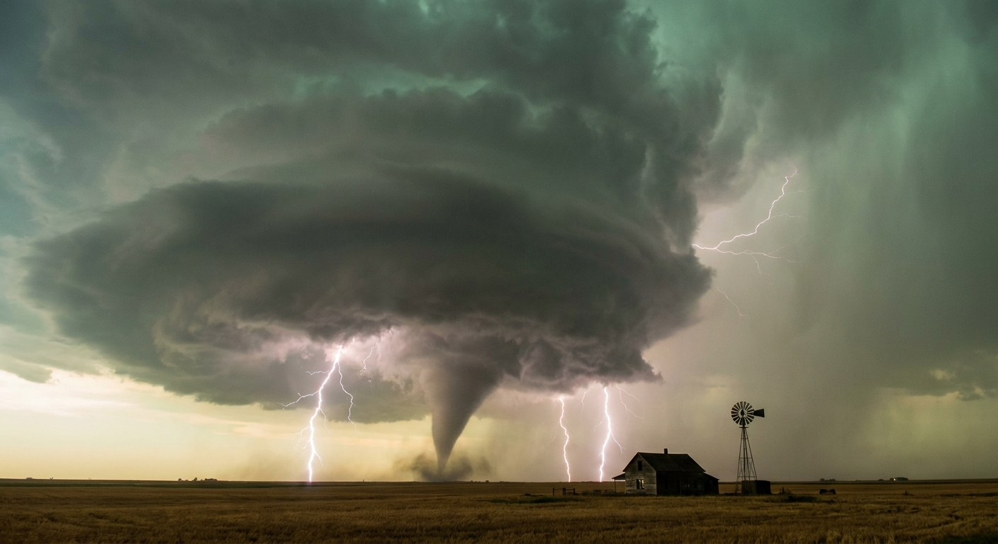
Stage 5: Tornado Maturity – The Vortex in Full
When a tornado fully develops, the storm has temporarily achieved a near-perfect configuration.
Visual Signs
Tornado shapes vary, but during maturity you may see:
- Classic cone or wedge shapes, often with violent debris clouds at the base.
- Clear, fast rotation in the funnel and surrounding cloud base.
- Powerful inflow—dust, leaves, or low scud streaming into the circulation.
Radar Clues
- Tight, intense velocity couplet at low levels.
- Strong reflectivity at the vortex location, sometimes with a distinct debris ball.
- Dual-pol CC showing a Tornadic Debris Signature (TDS).
Science in Play
- Maximum vertical stretching of vorticity.
- Strong, focused pressure drop in the core.
- Intense energy transfer between updraft, downdraft, and inflow.
Chasers should be at their most cautious here: the tornado can widen, shift track, or spawn satellite vortices.
Stage 6: Occlusion and Cycling – When One Dies, Another May Be Born
Many supercells don’t stop at one tornado. They cycle.
Visual Signs
- The original tornado begins to wrap in rain, weaken, or rope out.
- New lowering or wall cloud forms slightly downshear / east or southeast of the original.
- RFD surge may undercut the old circulation.
Radar Clues
- The original couplet weakens while a new area of rotation intensifies nearby.
- Hook echo may shift position as the storm reorganizes.
Science in Play
- The storm occludes the old mesocyclone—cool air wraps completely around it.
- A new zone of strongest updraft and low-level shear develops, seeding the next mesocyclone.
For chasers, this stage is deceptively dangerous. While you’re focused on the decaying tornado, a new, stronger circulation can be forming close by.
Stage 7: Decay – When the Engine Finally Stalls
Supercells die slowly, then suddenly.
Visual Signs
- Updraft loses its crisp structure, becoming ragged or elongated.
- Anvil thins, overshooting top vanishes.
- Storm may be overtaken by a line or undercut by a strong cold pool.
Radar Clues
- Mesocyclone broadens and weakens on velocity.
- Reflectivity core may elongate into a line or dissipate entirely.
Science in Play
- The storm may be undercut by cold outflow.
- Inflow air quality degrades—cooler, drier, less favorable for buoyancy.
Some storms remain severe with hail and wind well after their tornadic phase ends, but the organized rotational engine has shut down.
Chasing with the Life Cycle in Mind
Understanding these stages changes how you chase.
Early Stage Strategy
- Target dominant early updrafts in the best shear/instability overlap.
- Commit before the storm becomes one of many embedded in a mess.
Tornadogenesis Window
- Place yourself east or northeast of the forming wall cloud.
- Use both radar and visual cues to track the balance of RFD, inflow, and updraft.
Cycling Phase
- Don’t fixate on the dying tornado; look for the new wall cloud.
- Watch radar for shifting couplets—reposition early, not late.
Decay Stage
- Know when to let a storm go. Chasing a dying supercell too long can pull you out of position for new development.
Why This Never Gets Old
You’d think that after watching a few dozen supercells and tornadoes run through these stages, the novelty would fade. It doesn’t.
Every storm has its quirks: a stubborn cap that breaks late, a boundary interaction that spins things up early, an RFD that’s just warm enough to tip the scales toward a long-track wedge.
Tornado science gives us the framework. The field gives us the exceptions, the surprises, and the moments when a rotating wall cloud tightens in front of you and you realize you’re watching the atmosphere solve a complex equation in real time.
Learn the life cycle. Anticipate the chapters. Then go out there and read the sky with the respect it deserves.